How we created Burundi’s first drone
A young innovator turns his newfound technology skills into a pioneering solution for farmers
My interest in drones began with remote sensing during my later years in high school. I started experimenting with Arduino, a free and open-source electronics platform for building small projects out of curiosity. The ability to code a few lines and create a device that provided data about the environment intrigued me.
In college, I joined the drone club, where I gained hands-on experience with drone technology and three-dimension (3D) printing, also known as additive manufacturing.
In 2019, I interned with UNICEF Malawi at the Kasungu drone testing corridor. Working alongside industry leaders, I found inspiration to delve deeper. Since then, I have earned remote piloting licenses in Kenya and the United States.
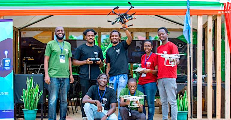
Last year, MediaBox, a top IT firm in Burundi, invited me to lead its drone and Internet of Things (IoT) workshop. That launched an incredible journey of innovation, culminating in one of my most remarkable inventions.
The firm approached me because it needed a custom platform to use in agriculture.
After roughly a month’s worth of effort, we workshopped a drone that could replicate the functions of a commercial drone. … Together, we constructed a pioneering drone, the first of its kind officially registered in Burundi.
Putting drones to work in agriculture
The use of drones in the agricultural sector has surged globally. According to Fortune Business Insights, analysts expect the worldwide agriculture drone market to grow by about 20 per cent compounded annually, from $4.98 billion in 2023 to $18.22 billion by 2030.
In Africa, 33 million smallholder farms contribute as much as 70 per cent of the food supply, yet many of them still rely on traditional methods for cultivating their crops.
Drone technology will empower farmers to enhance their crop yields, economize their time and try out predictive models to aid in planning.
Some farmers can even employ drones for tasks such as tracking irrigation, spraying insecticide and fertilizer, supervising livestock, and monitoring plant and soil health.
Developing our drone for farmers
The initial objective of my team of five engineers was to develop a versatile drone platform for use in various agricultural applications in Burundi. We harnessed our expertise in drone assembly, 3D printing and IoT applications.
After considering our options, we decided to engineer our own platform to deepen our understanding of drone technology. We wanted a platform that would be easy to repair, could carry different payloads and made the most of the open-source drone community.
Incorporating off-the-shelf components gave us great flexibility in designing and customizing our drone. We adopted a modular approach, with an eye toward continuous improvement.
To augment our workshop, we spent significant time learning the art of designing and printing 3D components.
Frequently, the specific items we needed were either unavailable in Burundi or not accessible in the quantities required. The experience of swiftly transforming our concepts into tangible objects under such circumstances has been invaluable.
Because we were creating an assembly process from scratch, our drone’s performance relied on our team’s deep comprehension of every component, along with mission planning and piloting expertise.
After roughly a month’s worth of effort, we workshopped a drone that could replicate the functions of a commercial drone, such as 20–25 minutes of flight time, automatic takeoffs and landings, emergency procedures, video feed for navigation, autonomously flying pre-planned missions and do-it-yourself (DIY) multispectral camera tasks, recording images invisible to the naked human eye.
Moreover, with our customized platform, we could carry any payload or sensor necessary for our missions. This capability was in stark contrast to commercial drones, often constrained by their pre-equipped sensors.
Our drone has successfully carried out multispectral missions, but we have used it mostly for general-purpose mapping, for farmers seeking accurate, high-resolution field maps.
The experience of swiftly transforming our concepts into tangible objects under such circumstances has been invaluable.The most valuable use of drones in agriculture is their ability to take aerial multispectral images.
Changing how farmers see their crops
A multispectral camera is a specialized device that captures images across various segments of the electromagnetic spectrum, unlike a standard camera, which records images only in the spectrum visible to humans.
Just as medical imaging gives doctors data on the condition of their patients’ hearts, a multispectral image gives farmers a wealth of information about their crop fields and soil conditions.
By the time our eyes see yellowing in a plant, it has been under stress for a considerable duration. Our multispectral imagery, however, alerts farmers to intervene at an earlier stage. That will help to increase yields and reduce hunger.
Unfortunately, entry-level multispectral cameras cost around $3,000 — unaffordable for aspiring technologists and smallholder farmers. That is why we developed our camera with off-the-shelf components to test the feasibility and usability of a DIY solution.
Today, our camera is one of the few DIY multispectral camera systems used in aerial drone photography on the Internet. Our workshop’s achievements underscore the substantial hurdles and rewards involved in constructing such camera systems.
Together, we constructed a pioneering drone, the first of its kind officially registered in Burundi.
Inventing an even better drone
However, our in-house DIY multispectral camera solution was not refined enough to capture the intricate details that farmers needed to assess plant health accurately. In response, we acquired a commercial multispectral drone.
We are now working on a platform that will allow farmers to schedule mapping missions, view previous maps, view reports on their plant health and have round-the-clock access to an agronomist to understand the relationship between their crops and the climate.
Recently, I was named one of three finalists in the 2023 Kenyan Agri-drone Business Competition, recognizing drone technology’s role in boosting the agricultural sector.
With effective community outreach and strong financial support, farmers will be able to benefit from this technology. As demand matures, commercially available multispectral drones will be more feasible and much easier to operate. For my part, I’m now scaling my drone business while conducting multispectral research.
For more information on COVID-19, visit www.un.org/coronavirus
Africa Renewal